
Table of Contents
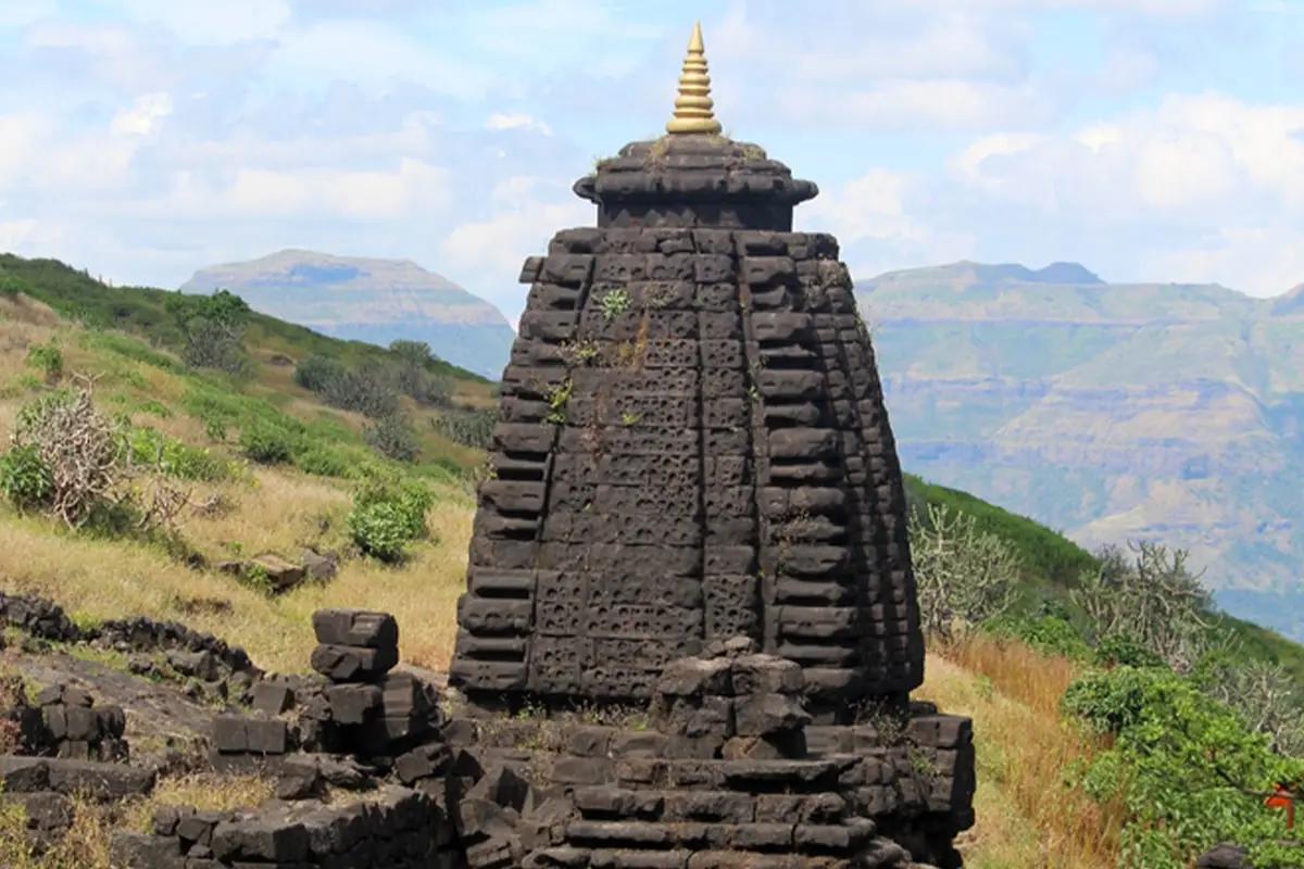
Raja Harishchandra Temple, properly the Harishchandreshwar Temple, is a Shiva temple on Harishchandragad, a hill fort in the Western Ghats of Maharashtra. The state tourism department’s page places the fort at about 1,422 m above sea level and lists three walking routes to it, from Pachnai, Khireshwar and Nalichi Vaat. The official pages checked do not describe a road to the temple, so plan this as a walk, not a drive-up temple visit.
Last checked: 4 October 2026, against the Maharashtra Tourism and Ahilyanagar district government pages and the Government of Maharashtra and Government of India gazette notifications listed in the sources at the end. Route times and conditions change with the weather, so confirm locally before you start.
Where is Raja Harishchandra (Harishchandreshwar) Temple?
The temple stands on Harishchandragad fort in the Sahyadri (Western Ghats) range. The Ahilyanagar district administration lists Harishchandragad as a tourist place in its district. The district was called Ahmednagar until the Maharashtra Revenue and Forests Department notified the new name on 8 October 2024, so older pages and maps may still say Ahmednagar. The district page itself still uses the old name in its text.
If you were looking for a different “Harishchandra” place, such as a ghat or a temple elsewhere, this page covers only the Harishchandreshwar Temple on Harishchandragad.
The government pages checked do not give GPS coordinates for the temple. A gazette notification on the eco-sensitive zone around the Kalsubai Harishchandragad Wildlife Sanctuary lists the base village Khireshwar at 19°25’32.958″ N, 73°42’56.750″ E. You can use that as a reference point in a map app. It marks the village, not the temple.
How to reach Harishchandreshwar Temple
Everyone starts from a base village and walks up. The Maharashtra Tourism page describes the approach to the base villages like this:
- From Mumbai: via the Mumbai–Nashik Highway (NH 160) through Malshej Ghat, then on to the base villages of Khireshwar or Pachnai.
- From Pune: via Narayangaon and Otur to Khireshwar, the starting point of the most popular route.
- By rail: the nearest stations named on that page are Kalyan and Igatpuri. From there you hire a private vehicle or a shared jeep to the base villages.
- By air: the closest airports named are Mumbai (Chhatrapati Shivaji Maharaj International) and Pune. The page says the onward journey from either airport involves multiple transfers.
The Ahilyanagar district page gives a different set: nearest airports Aurangabad and Pune (Shirdi with limited flights), Ahmednagar as the nearest railway station, and state transport buses from any Maharashtra State Road Transport Corporation bus stand. The two government pages do not agree, so check a live maps app and the bus or rail timetable for your own starting point.
Distance from Mumbai and Pune
| From | Maharashtra Tourism page | Ahilyanagar district page |
|---|---|---|
| Mumbai | 170 km | 218 km |
| Pune | 120 km | 166 km |
| Bhandardara | Not given | 50 km |
| Khireshwar | Not given | 8 km |
The two official pages give different figures and neither says which road or which base village the distance is measured to. Treat these as rough values and measure your own route on the day. The older “about 200 km from Mumbai and Pune” figure on this page was not on either official page and has been removed.
Trek routes to the temple
| Route | Starts at | Distance, one way | Time given | How the tourism page describes it |
|---|---|---|---|---|
| Pachnai | Pachnai village | About 3 km | 2–3 hours | The easiest route, with gentle slopes and waterfalls. Suggested for beginners and families. |
| Khireshwar | Khireshwar village, near Malshej Ghat | About 7 km | 6–7 hours | Moderate to difficult. Passes dense forest, rocky terrain and Tolar Khind. Best for experienced trekkers. |
| Nalichi Vaat | Not named on the page | About 8 km | 8–10 hours | Extreme. Rock climbing and technical sections that need ropes. For experienced climbers only. |
The previous version of this page gave 2 hours, 3–4 hours and 5–6 hours for these three routes. The tourism department’s figures are longer, especially for Khireshwar and Nalichi Vaat, so plan your daylight around the official times.
What is at the temple (according to Maharashtra Tourism)
- The Harishchandreshwar Temple is dedicated to Lord Shiva and built in the Hemadpanti style, with intricate carvings and a large Nandi sculpture at its entrance. The sanctum houses a shivling.
- The tourism page also describes a cave with a large Shiva Linga surrounded by very cold water. It says the cave has four supporting pillars that stand for the four Yugas, and that, by legend, only one still stands.
- Other features it names on the fort are Konkan Kada, a semicircular overhanging cliff, and Taramati Peak, the highest point of the fort.
How old is the temple?
The government pages date the fort, not the temple. Maharashtra Tourism says the fort’s origins go back to the 6th century, in the time of the Kalachuri dynasty, and that Sage Changdev is believed to have meditated here in the 14th century. The district page adds that various caves were probably carved in the 11th century AD, that the Marathas captured the fort in 1747, and that the Matsya, Agni and Skanda Puranas refer to Harishchandragad. Neither page states when the temple itself was built. Other websites give other dates, such as the 12th century, so no construction year for the temple is given here.
Temple timings, entry fee and rules
None of the government pages checked publishes darshan timings, an entry fee, a temple trust contact or rules for entering the temple. The previous version of this page said “open 24 hours”. That statement had no source and has been removed. Ask at the base village or the local forest office before you set out.
The central government’s 2017 eco-sensitive zone notification describes the Kalsubai Harishchandragad Wildlife Sanctuary as lying in Akole and Rajur tehsils of Ahmednagar district (now Ahilyanagar), covering 361.71 sq km. It lists leopard, wild boar and bonnet macaque among the wildlife of the sanctuary and the area next to it. The pages checked do not say whether a forest fee or permit applies to the walking routes, so ask the Forest Department locally.
Best time to visit and safety
| Season | What the tourism page says |
|---|---|
| October to February | Cool weather, green hills after the monsoon and clear views from Konkan Kada and Taramati Peak. Named as the best time and good for camping. |
| June to September (monsoon) | Waterfalls and mist, but the trails become slippery and difficult. Nalichi Vaat is especially dangerous because of rockfalls and strong winds. Rain gear and proper shoes are needed. |
| March to May | Hot and tiring in the daytime. Start early and carry plenty of water. |
Places near Harishchandragad named by the tourism department
- Malshej Ghat, close to Khireshwar village: a mountain pass known for waterfalls in the monsoon.
- Bhandardara: a hill station with Wilson Dam, Arthur Lake and Randha Falls. The district page puts it 50 km from the fort.
- Ajoba Hill Fort: a trek that the tourism page links to a belief about Sita’s stay during her exile.
Looking for other Maharashtra forts and treks? See the Bhimashankar trek guide, the Lingana fort trek, Padmadurg fort and all temple and fort guides.
Frequently asked questions
Where is Raja Harishchandra temple in Maharashtra?
It is the Harishchandreshwar Temple on Harishchandragad fort in the Western Ghats, in Ahilyanagar district (formerly Ahmednagar), Maharashtra. The usual starting villages are Khireshwar and Pachnai.
Raja Harishchandra temple kahan hai?
राजा हरिश्चंद्र मंदिर, यानी हरिश्चंद्रेश्वर मंदिर, महाराष्ट्र के अहिल्यानगर (पहले अहमदनगर) ज़िले में हरिश्चंद्रगड किले पर है। महाराष्ट्र पर्यटन विभाग के अनुसार वहाँ पहुँचने के रास्ते पैदल हैं: पाचनई से लगभग 3 किमी, खिरेश्वर से लगभग 7 किमी।
What is the distance of Raja Harishchandra temple from Pune and Mumbai?
Maharashtra Tourism gives 120 km from Pune and 170 km from Mumbai. The Ahilyanagar district page gives 166 km and 218 km. Both are official, but they differ, so check your own route on a maps app.
What is the nearest railway station to Harishchandragad?
Maharashtra Tourism names Kalyan and Igatpuri. The district page names Ahmednagar (Ahilyanagar). From the station you still need a private vehicle or shared jeep to reach the base village.
Can you drive to Harishchandreshwar temple?
You can drive to the base villages of Khireshwar and Pachnai. The government pages checked describe only walking routes from there and mention no road to the temple.
How long does the trek to Harishchandreshwar temple take?
According to Maharashtra Tourism, about 2–3 hours one way from Pachnai (about 3 km), 6–7 hours one way from Khireshwar (about 7 km) and 8–10 hours one way by Nalichi Vaat (about 8 km, with rope sections).
What are the temple timings?
No official timing was found. Check locally before you go.
What is the best time to visit?
The tourism department names October to February as the best time. The monsoon trails are slippery, and Nalichi Vaat is dangerous then.
Is Harishchandreshwar temple the same as Harishchandragad fort?
No. Harishchandragad is the hill fort. The Harishchandreshwar Temple is one of the structures on it.
Sources and how this page is checked
The facts above come from the Department of Tourism, Maharashtra, the Ahilyanagar district administration, the Maharashtra Revenue and Forests Department gazette of 8 October 2024 and the Ministry of Environment, Forest and Climate Change notification S.O. 1367(E) of 28 April 2017. Last checked 4 October 2026. This page will be updated when darshan timings or forest rules are confirmed.
